You shouldn't need hours of weather apps, maps, spreadsheets, and phone calls to figure out whether tomorrow's field plan still works.
AMI builds the dispatch plan around your sites, crews, operating standards, access conditions, travel time, and forecast windows.
When conditions change, AMI shows what changed, which work is affected, and whether the plan deserves another look.
You still make the decision. AMI does the analysis.
Use a real location. AMI Live uses current and forecast operational data, not canned demo results.
AMI Live lets you evaluate any location. AMI Pro continuously monitors the locations that matter to your operation.
Arrival falls inside the current operating window with sufficient time to work. Proceed with normal dispatch checks.
No login required · Live operational data
Field dispatch is still stitched together manually.
Weather changed, access failed, or the workable window closed before the crew got there.
Forecast apps, maps, road information, spreadsheets, site notes, crew availability, and phone calls.
There is rarely one record of what conditions were known and why the dispatch decision changed.
AMI turns those moving pieces into one operational plan.
The same dispatch desk — with and without AMI doing the analysis.
- Spreadsheets and sticky notes tracking sites, crews, and weather
- Best-guess weather from three apps — none checked at the actual arrival time
- Phone calls to the yard to ask whether the road is passable
- Crew rolls, then finds out at the site the work can't happen
- Standby day billed — mobilization wasted
- One screen — every site, every condition, current status
- Route, access, and arrival-time forecast checked before dispatch
- Viable operating window flagged automatically
- No-Go caught before the truck leaves the yard
- Mobilization spent only when the work can actually happen
From site intelligence to a dispatch plan.
Import your own portfolio, create a new location, or discover infrastructure through optional TowerMap Intelligence.
Upload your own CSV / coordinates / ArcGIS data, or simply create a new site, facility, access point, project location, staging area, or any field location you want to track. Optional TowerMap Intelligence can help you discover and research existing tower infrastructure when you need it. Once added to My Sites, AMI can begin tracking the operational intelligence behind that location and building history over time.
AMI finds viable operating windows and builds dispatch options around sites, crews, travel, route conditions, priorities, and cost.
Weather-Aware Plan or Route-Optimized Plan
Conditions do not stop changing after the plan is built. AMI refreshes the intelligence behind the work and shows:
See what AMI checks before the crew rolls.
AMI evaluates each assignment against the conditions that matter for the work being performed. Watch the decision build as each part of the mission is checked.
Know when to go, where to go first, and whether it's safe to dispatch at all.
Every dispatch run delivers both plans — you pick which to run.
AMI evaluates the same work through different planning strategies so the dispatcher can see the operational and cost tradeoffs before crews are committed.
- Sites sequenced to hit confirmed clear weather windows first
- High-risk sites pushed to later forecast days when conditions improve
- Avoids days exceeding your wind, precip, or visibility thresholds
- Zero weather-risk days in plan — crews work when conditions are confirmed
- Sites clustered using real road-matrix data, not straight-line proximity
- More sites per crew-day — maximizes output per mobilization
- Shorter total project duration, lower mobilization cost
Costs calculated from your actual crew rates, equipment, and mobilization inputs — not generic estimates.
← Scroll to compare →
| Metric | Weather-Aware | Route-Optimized |
|---|---|---|
| Total Sites in Plan | 20 | 20 |
| Sites Excluded (gate hold) Same — both plans exclude the same gated-out sites | 3 | 3 |
| Total Project Days | 8 days | 6 days |
| Total Drive Hours | 14.2 hrs | 10.5 hrs |
| Weather Risk Days | 0 | 2 days |
| Standby Risk Cost | $0 | $3,600 estimated exposure |
| Crew + Equipment Cost | $24,800 | $19,200 |
| Total Estimated Cost | $24,800 | $22,800 – $26,400* |
*Route plan cost range reflects weather-risk standby exposure. If both risk days proceed without incident, savings are real. If one turns into a standby day, the cost gap closes. AMI surfaces this so the dispatcher makes an informed tradeoff — not a guess.
Overrides and reasons can be recorded with the conditions that drove the recommendation.
One storm. Hundreds of locations. Know what is affected.
AMI Pro continuously evaluates monitored locations against changing conditions so operations teams can see where threats are developing and where attention may be needed first.
Explore AMI Pro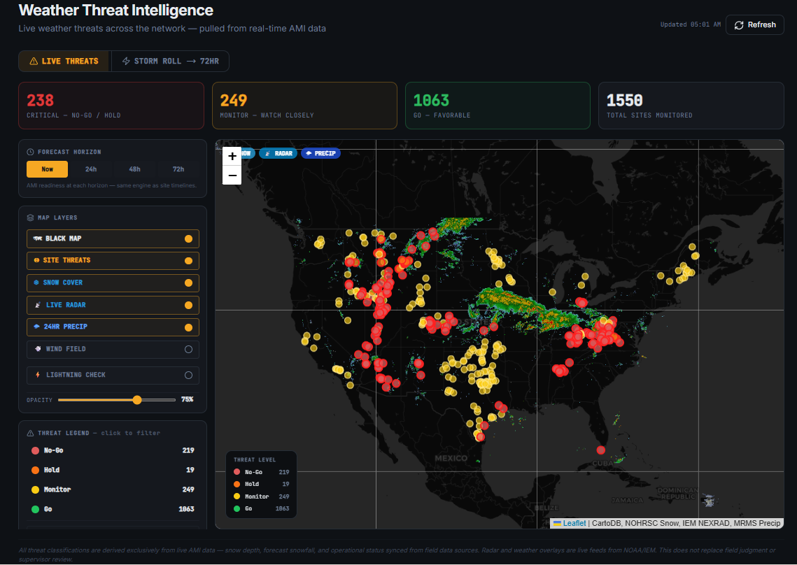
Will the work still be viable when the crew actually gets there?
AMI evaluates the destination at the estimated arrival time — not just current weather — then looks forward to see how much workable window remains. Same trip, two outcomes.
Leaving now places the crew onsite while conditions remain within operational limits. Proceed with normal dispatch checks.
AMI decision support. Final operational authority remains with your team.
Dispatching now risks a standby or failed mobilization. Recommend rescheduling to the next viable window — AMI flags the next one automatically.
AMI decision support. Final operational authority remains with your team.
A site that's Go at 6 AM can be No-Go at 10 AM. AMI checks the forecast at arrival so you don't find out after the drive.
One avoided standby day pays for months of AMI. The bad-outcome run above is a trip that doesn't leave the yard.
When today closes, AMI surfaces the next workable window automatically — so the crew goes when conditions will actually hold.
AMI gets stronger when it knows more about the work.
Track and build operational history around any location you manage — a facility, project site, access point, staging area, construction location, remote field location, or infrastructure asset. Import your own portfolio or create new locations directly.
Current and forecast weather, wind, visibility, lightning, wildfire, smoke, AQI advisories, snow, seasonal conditions, and other operational hazards.
Travel time, ETA conditions, wildfire exposure, snow exposure, operating-window-at-arrival analysis, and increasingly deeper road and access intelligence.
Crew observations, access notes, site knowledge, actual field conditions, and lessons from previous work feed the next decision.
Source freshness, confidence, and coverage are shown with the result. Missing information is not silently treated as clean data.
AMI came from the operations side of field work.
FirstGround Intelligence was founded by Jared Schexnider after years working across telecom infrastructure, GIS, field operations, broadband planning, and national-scale UAS inspection operations.
The same problem kept showing up: teams had plenty of information, but the information lived in different places.
The hard part was not finding another forecast. It was turning all of those moving pieces into a decision someone could actually use before the crew mobilized.
AMI was built around that problem.
Know when to go, where to go first, and whether it's safe to dispatch at all.
FirstGround is built around field reality — not replacing the people making the decision, but giving them better information before they have to make it.
See AMI track a real season as conditions change.
The 2025–2026 replay shows how monitored sites changed as snow accumulated, access deteriorated, and conditions later improved.
AMI surfaced Monitor and Hold states before sites became unworkable, giving dispatchers time to adjust before crews were already committed.
Snow is one example. AMI now evaluates changing conditions across the full field operation.
Built for field operations where timing, access, and conditions matter.
Find viable flight windows before pilots begin long mobilizations. AMI evaluates mission-specific weather, visibility, lightning, wildfire, smoke, arrival timing, and operating windows.
Evaluate wind, gusts, weather, snow/access conditions, and environmental hazards against climb-specific operating standards.
Evaluate sustained wind, travel time, access conditions, route exposure, and other constraints before mobilizing expensive equipment.
Sequence field work around operating windows, travel time, access conditions, site priorities, and nearby opportunities.
Understand when sites become accessible and when seasonal or environmental conditions are likely to affect planned work.
Monitor the portfolio, identify workable windows, compare dispatch options, understand what changed, and retain the decision record.
Start with one location. Scale to the whole operation.
Evaluate any location using live and forecast operational intelligence.
Save and continuously monitor your locations, apply your operating standards, track what changed, identify portfolio threats, and turn intelligence into dispatch decisions.
AMI can operate with your own sites and data. Optional FirstGround intelligence services add deeper infrastructure discovery and remote-access intelligence when your operation needs it.
Find infrastructure you already know about — and infrastructure you don't.
TowerMap Intelligence gives AMI a deeper view of the infrastructure itself. Search approximately 119,500 tower locations nationwide with available intelligence such as ownership, structure type, height, historical snow behavior, seasonal context, and environmental conditions.
TMI can also help teams discover infrastructure they may not already have in their own records — whether they are evaluating network expansion, entering a new market, looking for infrastructure near a target area, or researching a tower they have recently encountered.
Users can create their own site, facility, or field location and begin tracking it inside AMI — or select an existing tower from TowerMap Intelligence when infrastructure discovery is needed.
Find the infrastructure. Understand the site. Bring it into the operational plan.
The road on the map is not always the road the crew can use.
RouteMap Intelligence extends AMI beyond conventional navigation for remote field operations. Consumer navigation platforms are designed primarily for everyday travel. Remote infrastructure work can depend on forest roads, service roads, access roads, seasonal routes, private or field-known approaches, and other road systems that may not be represented well by conventional mapping.
RMI is being built to combine those additional road systems with AMI's operational intelligence so teams can evaluate not only how to reach the site, but what the crew may encounter along the way — route difficulty, snow exposure, wildfire exposure, access conditions, road class, restrictions, and other factors that can affect whether the route is practical for the mission.
The shortest route is not always the route the crew can actually use.
AMI Live itself does not require an AMI Pro subscription. Pricing is based on portfolio size and deployment frequency — we'll scope it on the call.
Full core AMI capability for a single crew or independent operator. One region, one dispatch queue.
For active regional contractors running 1–3 crews. The most common fit for tower, UAS, and crane operations.
Multi-crew, multi-project operations. Full ArcGIS sync, role-based access, unlimited dispatch runs.
Multi-region, multi-contract. Custom configuration, priority onboarding, SLA, and API access.
Common questions about AMI.
AMI Live lets anyone evaluate current and forecast operational conditions at a location. AMI Pro extends that intelligence across the locations your organization manages with continuous monitoring, configurable operating standards, What Changed tracking, portfolio threat intelligence, projects, dispatch planning, and operational history.
Try AMI on one real location right now, or let us run it against your actual sites and show what the dispatch looks like.